The Mount Umunhum Summit Project is an excellent reflection of the three foundational strands of Midpen's mission - to preserve open space, to protect and restore the natural environment and to provide opportunities for ecologically sensitive public enjoyment and education. It also illustrates the long-term commitment that is required to fulfill that mission.
Opened to public access in 2017, the Mount Umunhum summit is located within the Sierra Azul Open Space Preserve. One of the highest peaks in the Santa Cruz mountains at 3,486 feet, the summit was drastically altered in the 1950s when the U.S. military graded and flattened the summit to build Almaden Air Force Station. Midpen acquired the land in 1980 shortly after the base was decommissioned, preserving the land as open space. In 2009, Midpen received federal funding to clean up the site. The agency removed 3,000 cubic yards of hazardous materials, including lead paint, asbestos, fuel storage containers and PCB transformers, and deconstructed 13,680 tons of concrete, asphalt, wood and other materials, 97% of which were recycled or reused.
After Midpen staff spent three years listening to the public and researching potential options for the summit, the Midpen board of directors approved the Final Design Development Options for the Mount Umunhum Summit Project unanimously on August 26, 2015. Midpen then worked with experts to restore the summit to a more natural condition by recontouring and naturalizing the topography and reestablishing biodiverse habitats by planting native vegetation.

Midpen’s vision was for Mount Umunhum to join the ranks of the Bay Area’s great publicly-accessible peaks, like Mount Tamalpais, Mount Diablo and Mount Hamilton. To achieve that aspiration, the agency widened and repaved the 5-mile road to the summit, added new parking and staging areas, built welcoming multiuse trails, created in a Native American ceremonial space in partnership with the Amah Mutsun Tribal Band and developed an accessible overlook of Silicon Valley and the San Francisco Bay.
Visitor amenities at the summit also include:
- Multiple viewing coves that provide visitors with a variety of vistas
- ADA accessible pathways and trails
- Interpretive displays about the site’s unique natural, Native American and military histories
- Trailhead shelter with picnic tables
- Equestrian terrace
- Vault toilets


Stories of Mount Umunhum Audio Tour
The Stories of Mount Umunhum audio tour app allows you experience a virtual guided tour around the summit of Mt. Umunhum at your own pace. Learn how Mount Umunhum got its name and hear Air Force veterans, Indigenous peoples and others tell their personal stories about life on the mountain.
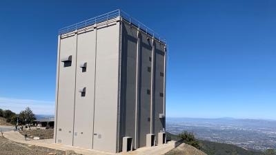
Radar Tower
In a special meeting on June 8, 2016, the Midpen Board of Directors voted to retain the tower and seal it to facilitate safe public access to the summit. Short-term safety repairs were completed in 2016 to stabilize the building. Following a structural, safety and hazardous material assessment, the board approved to move forward on long-term repairs that supported the retain and seal option previously approved by the board.
In March of 2022 the long-term repairs were completed. Significant repairs were necessary to reopen the area around the tower for educational and interpretive opportunities, prevent unsafe entry by wildlife and people and allow safe access by staff for future maintenance. This included the removal of hazardous materials, exterior wall concrete and rebar repairs and application of a weatherproofing exterior elastomeric coating. Additional work included the installation of a new roof, passive ventilation louvers with hoods and wildlife exclusion screens and interior safety improvements for staff access. Extensive work went in to restore the tower to its original esthetic look: The exterior color is a match to the federal standard of warm dark grey, replicating the color that the tower was during operation and the new exterior ventilation hoods match the previously installed hoods. The Umunhum Conservancy, a nonprofit dedicated to preserving the radar tower, donated $100,000 to offset a portion of the radar tower repair cost.
In 2016, the Santa Clara County Board of Supervisors listed the former Air Force radar tower that is located at the summit of Mount Umunhum on the County Heritage Resource Inventory to ensure its ongoing preservation. Part of a network of hundreds of Cold War-era radar stations, the five-story, reinforced concrete structure was once the centerpiece of the Almaden Air Force Station, supporting a 125 by 50-foot red and white radar sail that made five revolutions per minute for 22 years until it was removed after the base was decommissioned in 1979.