Sierra Azul Preserve / photo by Eric Bruce

Sierra Azul Preserve

Sierra Azul Preserve (Eric Bruce)

Overview

Download Map (Opens in new window)
Hours
Open a half-hour before sunrise until a half-hour after sunset, except the Mount Umunhum area, which is open from 7 a.m. until a half-hour after sunset. The Mount Umunhum area entrance gate closes at sunset in order to ensure visitors have time to safely exit the preserve before closing time.

The largest of the open space lands that Midpen manages, Sierra Azul Preserve protects more than 19,000 acres of wilderness in the Santa Cruz Mountains. Overlooking the Lexington Reservoir, Los Gatos and southern neighborhoods of San Jose, the preserve encompasses much of the Sierra Azul range and its foothills - topped by the 3,486-foot peak of Mount Umunhum. With 26 miles of multiuse trails for hiking, dog walking, biking and horseback riding, the varied landscape offers visitors views of serpentine grasslands, rocky and steep chaparral, dense stands of bay trees, shaded oak woodland forests, deep ravines and riparian corridors that surround the seasonal or year-round water flow. Prime mountain lion habitat, Sierra Azul Preserve also provides homes for deer, bobcats, coyotes and many other species of animals.

Image
Hiking: All Trails
Hiking: All Trails
Image
Bicycling: Designated Trails
Image
Equestrian: Designated Trails
Image
Dogs on Leash: Designated Trails
Image
Easy Access: Designated Trails
Image
Some parking
Parking: Designated Areas
Image
Restrooms: Available
Image
Kid Friendly
Kid Friendly
Image
Mt. Umunhum / photo by Lubor Ptacek
Mt. Umunhum (Lubor Ptacek)

Stories of Mount Umunhum

The Stories of Mount Umunhum audio tour app allows you experience a virtual guided tour around the summit of Mt. Umunhum at your own pace. Learn how Mount Umunhum got its name and hear Air Force veterans, Indigenous peoples and others tell their personal stories about life on the mountain.

The Stories of Mount Umunhum app is available for free on the App Store. We recommend downloading the audio tour app before your visit, because cell service and wireless connectivity can be limited in the area. The audio tour is also available on YouTube.

Preserve Highlights & Features

Image
Hikers on the east summit of Mount Umunhum / photo by Deborah Hirst
East summit, Mount Umunhum, Sierra Azul Preserve (Deborah Hirst)

Mount Umunhum

Mount Umunhum is one of the highest peaks in the Santa Cruz mountain range at 3,486 feet. You can hike to (or from) the summit on the multiuse Mount Umunhum Trail, which passes through mixed chaparral scrub, knobcone pine forest, coastal woodlands and steep, exposed terrain with cliffs and rocky outcrops. The summit's rocky, nutrient-poor serpentine soils are home to numerous endemic plant species, including rare flowering plants that reveal themselves each spring. From its summit, visitors can experience 360-degree views from the Pacific to the Sierra Nevada and learn about the mountain's long history with Native Americans, gold rush-era mining and the Cold War. The summit is accessible to visitors of all abilities.

Stories from the Preserves

Nature

Here are some of the plants and animals that other visitors have observed at this preserve and recorded in iNaturalist. Protected species may be excluded and some species may not yet have been observed. Help improve iNaturalist by adding your observations to the Midpen Biodiversity Index project

Join our e-mail list to stay up-to-date on this preserve and other Midpen news! 


Know Before You Go

Preserve regulations help provide a safe, enjoyable visit while protecting sensitive areas and wildlife. 

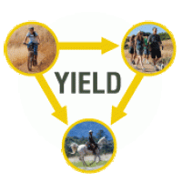
Image
YIELD. Bicycles yield to hikers and equestrians. HIkers yield to equestrians.

Share the Trail 

  • Use designated trails to avoid damage to natural resources and prevent injury. 

  • Avoid blocking the trail. Step aside to allow others to pass .  

  • Whether you’re walking or biking, always yield to equestrians. 

  • Leave no trace. Pack out what you pack in. Most preserves do not have trash cans. Littering is prohibited. 

  • Abuses of trail etiquette should be brought to the attention of a ranger or call the Midpen main office at 650-691-1200. 

Activities & Events

History

This preserve has the beauty and ruggedness of an unspoiled wilderness, but has been inhabited by people for a millennia. Native Americans have celebrated their traditions and histories at Mount Umunhum, which figures prominently in the Amah Mutsun people's creation story. German and Austrian refugees of the Franco-Prussian War settled in the area in 1870 to be near the New Almaden Quicksilver mining operations, developing the land for orchards and vineyards. From 1957 to 1980, the Mount Umunhum summit was the site of the Almaden Air Force Station, which served as part of a network of radar stations. The square concrete structure that is still visible was once the base for a large Cold War-era radar sail.

In addition to its unique habitats and geological features, Mount Umunhum has an important role in the region’s local and cultural history. For millennia, Native Americans have celebrated their traditions and histories at Mount Umunhum. The word “Umunhum” means “resting place of the hummingbird”, and signifies the delivery of fire to the Amah Mutsun people.

From 1957 to 1980, the summit was the site of the former Almaden Air Force Station where it served as part of a network of radar stations. The square concrete structure at the top of Mount Umunhum was once the base for a large Cold War-era radar sail. The summit has been closed since 1980 when the base was decommissioned. The base was acquired by the District and added to the Sierra Azul Open Space Preserve in 1986. In 2009, Midpen received federal funding, which enabled Midpen to clean up the site. Over 3,000 cubic yards of hazardous materials, including lead paint, asbestos, fuel storage containers and PCB transformers were removed along with13,680 tons of concrete, asphalt, wood and other materials, 97% of which were recycled or reused.